| example | ||
| .gitignore | ||
| .repo-runner.yaml | ||
| cache.go | ||
| cache_filesystem.go | ||
| CONTRIBUTING.md | ||
| Dockerfile | ||
| go.mod | ||
| go.sum | ||
| History.md | ||
| LICENSE | ||
| main.go | ||
| Makefile | ||
| map.go | ||
| postmap.go | ||
| README.md | ||
Luzifer / staticmap
staticmap is a webserver written in Go to generate static maps from OpenStreetMap tiles. Its API is inspired by the Google Static Maps API but supports only a subset of the functions and parameters described there.
API
All map operations are made against the /map.png endpoint of the server and are controlled by parameters:
| Parameter | Description |
|---|---|
center |
(required) Describes where to center the map. Must be given in decimal coordinates in format lat,lon (eg. 62.107733,-145.541936) |
zoom |
(required) Describes the zoom level of the map. Must be a number between 1 and 16 like in the OpenStreetMap itself |
size |
(required) Output format of the requested map. Must be two numbers joined by an x (eg. 600x300) - By default there is a limit to 1024px on each edge, you can set this in the parameters of the server. |
markers |
(optional) Marker definition, supports size and color attribute and marker positions must be given in format lat,lon. Elements of the marker definition are joined by a vertical bar. Valid sizes are tiny, mid, small. Valid colors are black, brown, green, purple, yellow, blue, gray, orange, red, white or a hex color in 3 or 6 letter notation: 0x333, 0x333333. |
Example of a map having two different markers
/map.png
    ?center=53.5438,9.9768
    &zoom=15
    &size=800x500
    &markers=color:blue|53.54129165,9.98420576699353
    &markers=color:yellow|53.54565525,9.9680555636958
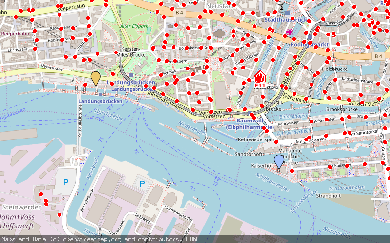
The map center is set to a coordinate within Hamburg, Germany with a zoom level of 15. Additionally there are two markers set: One blue marker to the Elbphilharmonie, one yellow marker to the Hard Rock Cafe Hamburg. The example above (of course without the line breaks) produced this image:
Overlay support
Starting with version v0.4.0 the generator supports map overlays for tiles based on transparent background (like OpenFireMap, OpenSeaMap, ...). As those requests would be too complex for GET requests and are also not a common usecase they are implemented as POST requests containing a JSON object.
This example is generated with OpenFireMap overlay tiles using the example/postmap.json file:
Setup
- There is a Docker container available:
luzifer/staticmap - This repository has precompiled binaries attached in the releases section
- You can
go get github.com/Luzifer/staticmapthe project and build it from source
Afterwards just see staticmap --help (or docker run --rm -ti luzifer/staticmap --help) for commandline parameters.


