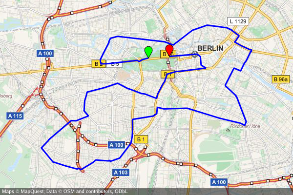
A go (golang) library and command line tool to render static map images using OpenStreetMap tiles.
## What?
go-staticmaps is a golang library that allows you to create nice static map images from OpenStreetMap tiles, along with markers of different size and color, as well as paths and colored areas.
go-staticmaps comes with a command line tool called `create-static-map` for use in shell scripts, etc.

## How?
### Installation
Installing go-staticmaps is as easy as
```bash
go get -u github.com/flopp/go-staticmaps
```
For the command line tool, use
```bash
go get -u github.com/flopp/go-staticmaps/create-static-map
```
Of course, your local Go installation must be setup up properly.
if err := gg.SavePNG("my-map.png", img); err != nil {
panic(err)
}
}
```
See [GoDoc](https://godoc.org/github.com/flopp/go-staticmaps) for a complete documentation and the source code of the [command line tool](https://github.com/flopp/go-staticmaps/blob/master/create-static-map/create-static-map.go) for an example how to use the package.
### Command Line Usage
Usage:
create-static-map [OPTIONS]
Creates a static map
Application Options:
--width=PIXELS Width of the generated static map image (default: 512)
--height=PIXELS Height of the generated static map image (default: 512)
-o, --output=FILENAME Output file name (default: map.png)
-t, --type=MAPTYPE Select the map type; list possible map types with '--type list'
-c, --center=LATLNG Center coordinates (lat,lng) of the static map
-z, --zoom=ZOOMLEVEL Zoom factor
-b, --bbox=NW_LATLNG|SE_LATLNG
Set the bounding box (NW_LATLNG = north-western point of the
bounding box, SW_LATLNG = southe-western point of the bounding
The `--marker` option defines one or more map markers of the same style. Use multiple `--marker` options to add markers of different styles.
--marker MARKER_STYLES|LATLNG|LATLNG|...
`LATLNG` is a comma separated pair of latitude and longitude, e.g. `52.5153,13.3564`.
`MARKER_STYLES` consists of a set of style descriptors separated by the pipe character `|`:
-`color:COLOR` - where `COLOR` is either of the form `0xRRGGBB`, `0xRRGGBBAA`, or one of `black`, `blue`, `brown`, `green`, `orange`, `purple`, `red`, `yellow`, `white` (default: `red`)
-`size:SIZE` - where `SIZE` is one of `mid`, `small`, `tiny`, or some number > 0 (default: `mid`)
-`label:LABEL` - where `LABEL` is an alpha numeric character, i.e. `A`-`Z`, `a`-`z`, `0`-`9`; (default: no label)
-`labelcolor:COLOR` - where `COLOR` is either of the form `0xRRGGBB`, `0xRRGGBBAA`, or one of `black`, `blue`, `brown`, `green`, `orange`, `purple`, `red`, `yellow`, `white` (default: `black` or `white`, depending on the marker color)
### Paths
The `--path` option defines a path on the map. Use multiple `--path` options to add multiple paths to the map.
--path PATH_STYLES|LATLNG|LATLNG|...
or
--path PATH_STYLES|gpx:my_gpx_file.gpx
`PATH_STYLES` consists of a set of style descriptors separated by the pipe character `|`:
-`color:COLOR` - where `COLOR` is either of the form `0xRRGGBB`, `0xRRGGBBAA`, or one of `black`, `blue`, `brown`, `green`, `orange`, `purple`, `red`, `yellow`, `white` (default: `red`)
-`weight:WEIGHT` - where `WEIGHT` is the line width in pixels (defaut: `5`)
### Areas
The `--area` option defines a closed area on the map. Use multiple `--area` options to add multiple areas to the map.
--area AREA_STYLES|LATLNG|LATLNG|...
`AREA_STYLES` consists of a set of style descriptors separated by the pipe character `|`:
-`color:COLOR` - where `COLOR` is either of the form `0xRRGGBB`, `0xRRGGBBAA`, or one of `black`, `blue`, `brown`, `green`, `orange`, `purple`, `red`, `yellow`, `white` (default: `red`)
-`weight:WEIGHT` - where `WEIGHT` is the line width in pixels (defaut: `5`)
-`fill:COLOR` - where `COLOR` is either of the form `0xRRGGBB`, `0xRRGGBBAA`, or one of `black`, `blue`, `brown`, `green`, `orange`, `purple`, `red`, `yellow`, `white` (default: none)
The `--circles` option defines one or more circles of the same style. Use multiple `--circle` options to add circles of different styles.
--circle CIRCLE_STYLES|LATLNG|LATLNG|...
`LATLNG` is a comma separated pair of latitude and longitude, e.g. `52.5153,13.3564`.
`CIRCLE_STYLES` consists of a set of style descriptors separated by the pipe character `|`:
-`color:COLOR` - where `COLOR` is either of the form `0xRRGGBB`, `0xRRGGBBAA`, or one of `black`, `blue`, `brown`, `green`, `orange`, `purple`, `red`, `yellow`, `white` (default: `red`)
-`fill:COLOR` - where `COLOR` is either of the form `0xRRGGBB`, `0xRRGGBBAA`, or one of `black`, `blue`, `brown`, `green`, `orange`, `purple`, `red`, `yellow`, `white` (default: no fill color)
-`radius:RADIUS` - where `RADIUS` is te circle radius in meters (default: `100.0`)
-`weight:WEIGHT` - where `WEIGHT` is the line width in pixels (defaut: `5`)
A map with a marker at "N 52.514536 E 13.350151" with zoom level 14 (no need to specify the map's center - it is automatically computed from the marker(s)):